


DAY OF
HIKING
Monarch Butterfly Trail

Trail of
Distance: 10.68km
Total time: 3h 53 min.
Positive gradient: 77m
Maximum altitude: 87m
Circular route
HIKING ROUTE - 1 DAY

THE MONARCH BUTTERFLY
Request more information

To take the trail and leave from the La Gloria estate, we must head to the starting point 23 minutes by car along the CA-8200 road, heading northwest and then along the A-405 and CA-5181 to the Venta de la Cantina on the Almoraima road, in the municipality of Pueblo Nuevo de Castellar de la Frontera.
Here we parked our car and just behind the inn, we started the trail.
The route begins by going down from the road behind the inn to the Guadarranque River.
The Guadarranque River, from the Arabic Wadi-Ramke, river of the mares, with a length of approximately 43 km, is born in the Buenas Noches Estate, in the municipality of Jimena de la Frontera, in the heart of the Alcornocales Natural Park, and, after crossing a large reservoir, reaches this area between the sandstone mountains and the river plain.
We walked along this entire part of the trail along the river through a large riverside forest, surrounded by alders, ash trees, oaks and white poplars.


You will also be able to see some Clathrus archeri mushrooms, rare in the area, with a very striking strong orange colour, even more so because of their stinky smell.
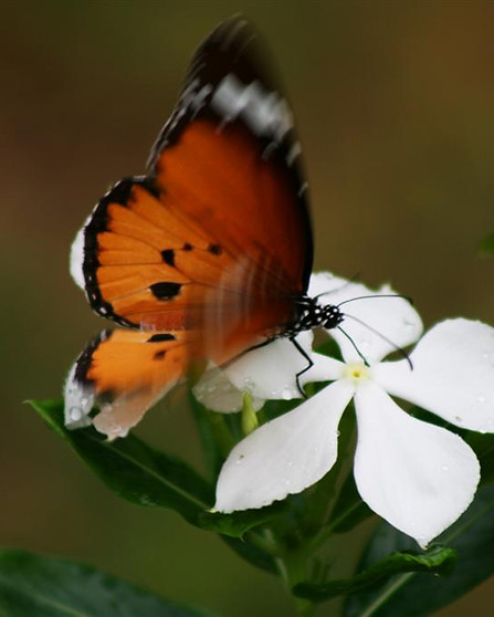
Throughout the route we can see a large number of monarch butterflies, as if justifying the name of the trail, some large turtles, mallards and, with luck, some deer in one of the open spaces along the trail.
The monarch butterfly (Danaus Plexippus), one of the largest and most beautiful butterflies that we can observe in our environment, is above all known for its great migration of thousands of kilometers in North America to spend the winter in a small place in Mexico, where millions of individuals can be concentrated.
Its only populations on the European continent are found in the area of the Strait of Gibraltar, whose existence has been documented recently, since 1994.


Finally we reach the Jarandilla bridge, where this path ends. We cross the bridge and turn right, we climb up until we reach the road.
For those who love hiking, we inform you that from here you can continue in several directions: one of them is to go up to Castellar Castle, through the Roman Road; another is to cross the Jarandilla bridge and head towards the Cerro de la Casa del Moro; the third option is to cross the Jarandilla bridge and head towards Los Riscos de los Bazanes; a fourth alternative is to continue towards El Cañuelo and Dehesa Boyal; and, finally, another option is to return along the old road, first, and then along the current road, which goes from Venta la Jarandilla to Venta de la Cantina, approximately 6 km. This last option was what we did.
You can take the return route along an old road, surrounded by many trees, especially eucalyptus trees; passing through a safety zone; crossing under the CA-P-5231 road and later joining it.
You walk along the asphalt, always on the left shoulder, enjoying the Finca de la Almoraima. On the left, you can see a large gate that leads to a channelling area of the Guadarranque River; you pass by the vicinity of the Casa Convento and, on your right, you pass the Brigada de Refuerzo de Incendios Forestales (BRIF-A) of the Almoraima, with a helicopter included. Until you reach the vehicles.

The assessment that each person makes of a route after having completed it is very subjective, since it depends on many factors: age, physical preparation, technical preparation, required equipment, characteristics of the terrain, weather conditions, etc.; therefore, it is necessary to state that what is described in this story and the parameters that appear in it (time, distance, degree of difficulty, GPS tracks and waypoints) are merely informative / indicative and, therefore, it is the responsibility of whoever wants to do it to take the appropriate measures.


INVEST IN YOUR